Click here for information about the 2025 Wine, Whiskey & Ale Fest

  • 502-543-8656
  • [email protected]
  • General Info
  • Group Tours & Meetings
  • Blog
  • My Account
  • General Info
  • Group Tours & Meetings
  • Blog
  • My Account
Bullitt County Kentucky Trademark Logo
  • What To Do
    • View Bullitt County Directory
    • The Wine, Whiskey & Ale Trail
    • Wine, Whiskey & Ale Fest
    • Visit Bernheim Forest & Arboretum
    • Visit Historical Bullitt County
    • Choose Your Experience
    • Play the Great Big KY Adventure Game
  • Lodging
  • Dining
  • Events
  • Contact
DOWNLOAD DIGITAL PASS
Bullitt County Kentucky Trademark Logo
Menu

Fort DeWolf Historical Marker

  • Bookmark
  • Profile
  • Reviews 0
  • prev
  • next
  • Website
  • Get directions
  • prev
  • next
Description

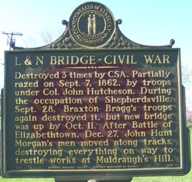
This historical marker marks the location of Fort DeWolf on the L & N railroad at Shepherdsville. The Union army begain protecting the L & N Railroad from the beginning of the war. Once Nashville was taken the railroad became a vital supply line for Federal troops in Tennessee. It was equally important for the Confederacy to disrupt that line of supply as early and often as possible. By December 1862, the Union army had constructed six stockades between Elizabethtown and Shepherdsville (Big Run trestle and Sulphur Fork trestle both on Muldraugh Hill, Lebanon Junction, Belmont, Bardstown Junction and Shepherdsville). The stockades were manned only with infantry and proved woefully inadequate against troops with artillery. In March 1863 the Union army proposed upgrading the stockade in Shepherdsville by “… erect[ing] an artillery and infantry parapet, together with a line of rifle pits connecting it with abattis or entanglements … and the establishment of artillery.” The fort was only partially finished in July 1863 when Morgan attacked and burned the stockade at Bardstown Junction. During Morgan’s July 1863 raid, Major Israel N. Stiles, commander of the Union troops in the area, ordered his men at Belmont and Bardstown Junction to Shepherdsville. He believed that his unfinished earthwork and single cannon offered more protection than the stockades. Fort DeWolf was improved and more artillery was added, as a result it was never again threatened by Confederate forces. Fort DeWolf was named for Lieut. William DeWolf, 3rd US Artillery, who was killed at Williamsburg, Virginia. The completed fort was across the Salt River south of Shepherdsville. Fort DeWolf was constructed so that the L & N literally passed through it. Between the fort and the river was a barracks and along the railroad a brick water tank. Constructed between the river and the fort was a line of inclined pallisades, a wooden wall five feet high, made of sharpened posts. The line of palisades was designed to protect the barracks and to keep an attack from flanking the fort.

Location
  • 605 Preston Hwy, Shepherdsville, KY 40165, USA

    Get Directions
Contact Information
  • Address: 605 Preston Hwy, Shepherdsville, KY 40165, USA
  • Website: https://bullittcountyhistory.org/hmarkers/fortdewolf.html
Photos
Fort DeWolf
Categories
  • Historical Markers
Region
  • Shepherdsville
  • No comments yet.
  • Add a review

    Leave a Reply · Cancel reply

    Your email address will not be published. Required fields are marked *

    Your Rating

    Upload images

    You May Also Be Interested In

    Gallery image

    L & N Bridge-Civil War Historical Marker

    • Shepherdsville
    • 605 Preston Hwy, Shepherdsville, KY 40165, USA
    • https://bullittcountyhistory.org/hmarkers/lnbridge.html
    • Historical Markers
    Gallery image

    Old Stone Bank

    • Shepherdsville
    • 416 South Buckman Street, Shepherdsville, KY, USA
    • Museum
    Gallery image

    “County Named, 1796” Historical Marker

    • Shepherdsville
    • 300 S Buckman St, Shepherdsville, KY 40165, USA
    • https://bullittcountyhistory.org/hmarkers/countynamed.html
    • Historical Markers
    Team Kentucky Logo White
    Trip Advisor Logo White
    Bourbon Horses and History Logo White
    Kentucky Black Trailblazers Logo

    © Shepherdsville/Bullitt County Tourist & Convention Commission

    • Privacy Policy
    • Sitemap

    Cart

    Bullitt County Kentucky Trademark Logo
    • What To Do
      • View Bullitt County Directory
      • The Wine, Whiskey & Ale Trail
      • Wine, Whiskey & Ale Fest
      • Visit Bernheim Forest & Arboretum
      • Visit Historical Bullitt County
      • Choose Your Experience
      • Play the Great Big KY Adventure Game
    • Lodging
    • Dining
    • Events
    • Contact
    • General Info
    • group tours & meetings
    • blog
    • My Account
    Download Your Digital Pass